Trail Guide to Sligo Creek Stream Valley Park
This guide has been developed to help the user better appreciate the natural and historic features of the park and adjacent areas. Often there exist deeper treatments of topics touched on in the guide that can be found on this website or elsewhere. These are generally noted in the text. The guide follows Sligo Creek from its headwaters to where it joins the Northwest Branch of the Anacostia River after flowing better than eight miles.
To fully enjoy your visit to the park, please go slowly, reference guidebooks, and wear sensible footwear. If you have comments on the guide, please send them to [email protected].
I am deeply grateful to Clair Garman and other members of Friends of Sligo Creek for their help with the guide and maps. However, do not blame FOSC or any part of the Montgomery County Government for any errors, omissions, bad advice, or other quibbles you may have with the guide. I take all responsibility for that.
Bruce A. Sidwell September 8, 2016
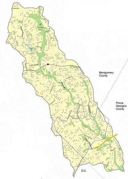
There are ten sections of this guide; each has its own map. Select from the list below.
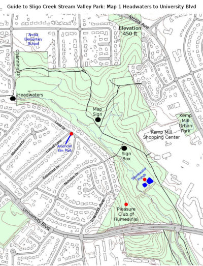 The hiker-biker path (and stream) travel some 0.7 miles in this section. Just south of the end of Channing Drive near Arcola Elementary School, and only a few feet into the northwest corner of the park is a sizable concrete outlet that is about as close as one can reasonably get to the headwaters of Sligo Creek. Like most urban streams, large portions of it have been confined to storm drains so that the area could be developed, in this case into single family houses beginning in the early 1960s. There is unrestricted parking along Channing and adjacent streets.
(BTW, to get to Wheaton Regional Park, turn your back on the outlet, proceed north on Channing, veer left on Ventura Ave, then go north on Nairn Rd to the terminus of the paved trail into Wheaton Park.)
The hiker-biker trail for Sligo begins off Channing about 150 feet north of the headwaters. Follow it east as it divides the Arcola Park playground from the woods of Sligo Creek Park. Though “second growth” (actually, maybe fourth growth), the woods are pretty impressive. There are lots of Tulip Trees (Lirodendron tulipifera) and oaks that are often a good 80-100 years old. In addition, there are a variety of other deciduous trees including Black Cherry (Prunus serotina), Black Gum (Nyssa sylvatica), maples, Black Locust (Robinia pseudo-acadia), and a few old Virginia Pines (Pinus virginiana) scattered about. The FOSC website contains a thorough survey of trees and other plants done by John Parrish and friends in 2003. Take a look at “Plants of Sligo Creek”. Full or edited checklists of trees can be printed out.
The understory contains a smattering of American Holly (Ilex opaca), Spicebush (Lindera benzoin), and other shrubs. From a distance, the shrub, the Oregon Grape Holly (Mahonia aquifolium) appears like a better-looking holly. It is not related and is in fact, a species naturally found in the Pacific Northwest. Like many non-natives, it was planted as a swell-looking addition to back-yards. Its berries were eaten by birds who unceremoniously deposited the seed in the park. Now these shrubs are providing competition to native shrubs. Why is this bad? Since non-natives did not co-evolve with the native eco-system they don’t fit as well with the needs of native birds, insects, and other animals and plants. The non-natives also often out-compete native plants because they aren’t fed on by native grazers such as insects and deer.
After about 400 yards, the paved trail makes a sharp turn south and heads gradually downhill. The surrounding forest floor on the right becomes a wetland that is home to ferns and skunk cabbage. There are also some very small ponds that provide habitat for amphibians. In Spring, there may be gelatinous masses containing eggs of Eastern American Toads (Bufo americanus), Spotted Salamanders (Ambystoma maculatum), and Wood Frogs (Rana sylvatica). For more information go to “Animals” on the FOSC website.
At the bottom of the hill, another paved trail comes in from the left. At the intersection is a sign-map of the complete hiker-biker trail in the Montgomery County section of Sligo Park. If you take this side trail it leads uphill to a playground and eventually by way of neighborhood streets to a recreational complex of Wheaton Regional Park across Arcola Avenue. Before it gets to the playground, the trail passes through a grove of young trees, mostly Red Maples (Acer rubrum). To the east of the grove is a tiny side branch of Sligo Creek. It peters out just shy of Arcola Avenue. Arcola at this point is laid on a ridge that is probably the high point of the watershed, about 450 feet. The ridge divides the Sligo watershed from the Northwest Branch watershed to the east.
The main trail south past the intersection passes more wetlands and moist forest floor under a dense canopy of Tulip Trees, maples, and a variety of other deciduous trees. Near Kemp Mill Shopping Center, FOSC has a handsome “kiosk” containing information about the park and our organization, including brochures.
A little north of the kiosk, a paved side trail leads west through the park. This side trip goes across a bridge over the creek, and connects with the neighborhood. After traveling right on Ladd Street for a block, on the left is a community project called the “American Elm Park”.
Beginning about 2000, community volunteers led by Kathy Michels and Ed Murtagh restored the triangular parcel. When they started, the ground was so compacted, eroded, and filled with construction debris that very little could grow there. It was an eyesore and of no use for habitat. After removing debris and adding leaf mulch, native plants were put in. It is called American Elm Park because it contains several young Dutch elm disease resistant trees (Ulmus americana). Now the park is attractive and useful for birds and butterflies. A couple of signs explain the restoration of the site and its benefit as habitat and to enhance local water quality. Much more information is available on this website. To find it go to the electronic version of Map 1 and click on the button for “American Elm Park”.
Also at the kiosk, one can see the Kemp Mill Shopping Center. At the junction of the parking lot and Arcola Avenue a new Kemp Mill Urban Park was completed in Spring of 2017. It features three ponds with plantings of native plants.
Back on the main trail in the park, traveling downstream past the intersection with the side trail, one can see an earthen dam through the trees on the right. It creates the University Boulevard Stormwater management ponds. In addition to managing excess flow during storms, the two adjacent ponds provide habitat for reptiles, amphibians, birds, and other critters. For more information click the button on Map 1 for Stormwater ponds.
Across the dam, about 50 yards southwest up the slope, one can find the ruins of the “Pleasure Club of Fiumedinise“. The club was built in 1923 by men with connections to the Sicilian village of Fiumedinise. For about 40 years it was a place where the guys could come to reminisce, play bocce ball, and sample home-made wine and beer. The Map 1 button, “Fiumedinise”, links to more about this piece of history. While on this side of the creek, during the growing season, you should admire what seems to be the only stand of Cinnamon Fern (Osmunda cinnomamomea) in Sligo Park.
As you have traveled through this portion of the Sligo Creek Park, we hope you remembered to bring your binoculars and a bird guide. In addition to more familiar backyard species, there are herons, hawks and other raptors, several woodpecker species including Pileated, and numerous others not likely to be seen from your backyard window. Thanks to the variety of habitats, many of the 68 species that breed in the park can be found here. In addition, there are many more species seen during Spring and Fall migration. Find out more by looking under “Animals of Sligo Creek” as well as “Sightings” under the Natural History section of this website. In “A Birder’s Guide to Montgomery County, Maryland,” the Montgomery County Chapter of the Maryland Ornithological Society lists this part of the park as a “Little Treasure”.
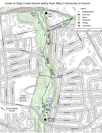
This portion of the trail is about 0.9 miles (not allowing for tempting side jaunts). Just after exiting the University Boulevard crosswalk, there is a large sign that shows the hiker-biker trail from Wheaton Regional Park to Northwest Branch in Prince George’s County. The main trail briefly follows the highway sidewalk west across the parkway and creek, then continues downstream.
However, one may also take a paved side trail leading directly from the hiker-biker sign on the left side of the parkway past a kiosk and an exercise station then to Breewood tributary. Following the tributary uphill away from the parkway, one can see a recently completed stream restoration that extends for several hundred yards into Breewood Park. Just a few years ago the stream was a badly eroded slash in the hillside. Now after considerable effort from the County government and volunteers, the stream bed has been restored, invasive plants removed, and many young trees planted. To gauge the success of the project and other storm water improvements in the adjacent neighborhood, a water quality measuring device operates near the confluence of the tributary with Sligo Creek. The white structure looks a bit like a small refrigerator with tubes leading to a pool in the stream. There is more about the whole Breewood Tributary Restoration Project on this website in the Stormwater section.
An unpaved trail known as the “Northwood Chesapeake Bay Trail” leads away from Sligo through the Breewood Park. The trail crosses University Blvd, then continues past Northwood High School, and eventually connects with Northwest Branch. To follow it look for red blazes. A map and more information on the trail can be searched on this website.
Back on the main trail, just a hundred or so feet from where it leaves University Boulevard, one can look back into the substantial double tunnel that carries Sligo Creek under the six-lane road. Also at that point on the other side of the creek there are several “knees” at the edge of the creek bed. They are associated with a Bald Cypress tree (Taxodium distichum) a few feet further up the bank. There are a few dozen specimens of this tree in the park, some fairly large. There are also some White Pine (Pinus Strobus), a few Eastern Hemlock (Tsuga canadensis), and some Norway Spruce (Picea Abies). What these trees all have in common is that they are not native to the Sligo watershed. They likely resulted from efforts of fans of these plants, some in government, some private citizens. This all-too-human trait to “improve” the park is apparent at many levels. More examples later.
A bit farther down the trail there is a bench bearing a plague reading “James and Mary Lee Lived here on Chestnut Ridge 1741-1764”. The bench was provided through efforts of their descendants a few years ago. On the website under “History/ Memorials in Sligo Park”, one can find the story behind this tribute, as well as numerous similar efforts near the trail.
By this point, the creek is more substantial than the little waterway seen near the headwaters. The bed alternates between stretches of “riffles” and slack water pools. A check of tiny critters at these locations shows some differences among what species are adapted to the differing conditions offered. For example, riffles contain more oxygen and less mud than pools. Also in this area ancient bedrock is visible in the creek bed.
There are also differences in the tree species found near the creek versus those further upslope. The dominant trees by the creek include Tulip Trees, Sycamore (Platanus occidentalis), and Red Maples since they tolerate wet feet. In drier conditions, oaks prevail. Even among oaks there are distinctions, with Chestnut Oaks (Quercus Prinus) and White Oaks (Quercus alba) generally found higher on a ridge than Red Oaks (Quercus rubra).
Identifying trees, while perhaps less exciting than watching for warblers, has its own rewards. Plus they are large and immobile, a major plus. On the website, under “Plants and Animals/ Trees of Sligo Park”, there is a checklist of 60 or so native trees that have been found by experts. The list also notes abundance and general location. However it is not a key. For that, you need to bring a guide. On a hike, leaves are reliable for identifying to species, however looking at flowers, bark and buds, plus other characteristics can be very helpful. Even in winter most trees give themselves away. An interesting small tree found near the creek here and there is sometimes called the “muscle-tree” for the twist and feel of the trunk (also known as American Hornbeam Carpinus caroliniana).
Some trees along the trail are left-overs from an earlier time when this part of the woods was more open. Virginia Pine, Eastern Redcedar (Juniperus virginiana), and Black Locust (Robinia pseudo-acacia) require lots of light to germinate and grow. They are often called “pioneer” species because in this part of the country they are among the first trees to colonize an abandoned field. The succession of trees that follow favor ones that tolerate more shade.
After walking a bit over a half-mile from University Blvd, just as the woods give way to a ball field on the right, there is a wet area near the creek where in early March, one can find skunk cabbage in bloom.
Just ahead, the Dennis Recreation Center comes into view across the creek. The flats and sandbars by the stream here are good for finding tracks of mammals including deer, raccoon, and opossum; maybe even beaver, muskrat, and fox; possibly even mink. Between the trail and the creek there is a wetlands where Skunk Cabbage blooms in late winter.
This area is also a good place to begin looking for fish in earnest. You will be sorely disappointed if you bring a pole since we are talking mainly about minnow-sized creatures. However these small fish are generally visible to the patient observer. The last century has not been good to the fish population due mainly to problems with water quality and excessive storm water. Historically there were likely more than 20 species of fish in the stream but by 1984 only three species were found. Beginning in the 1990s regular efforts were made by government biologists to transfer fish from the cleaner reaches of Northwest Branch. Now there are thought to be about a dozen established species in Sligo Creek. At the little beach just upstream from the Rec Center, in 2004 and 2007, FOSC volunteers assisted Montgomery County biologists to corral in Northwest Branch more than 300 fish representing seven species of very small but lively fish. They were carefully released by small children into the relatively deep pool of Sligo by the beach. Many photos were taken and refreshments served. See Fish in the “Animals of Sligo Creek” section of this website for details. More about bigger fish later.
Near the footbridge there is a big landscaped depression engineered to capture and filter storm water that washes down from the neighborhood streets. An interpretive sign shows how it works. There is another smaller rain garden nearer to the parkway.
After a half-mile side trip west on Dennis Avenue, to the left there are three ponds to ponder. They were built in 1990 to intercept floods from large storms. Wheaton Branch has around 800 acres of land to drain; fifty percent of it “impervious”. This includes the heavily developed business area of Wheaton. Water from Wheaton Branch travels under Dennis, then hits the first pond, then the second, then the third. The storm-water is thus slowed and dissuaded from slamming into Sligo Creek. At the third pond only water from the top cleaner portion of the pond is allowed to continue its travel down the Branch. More information is available on how the system works by activating the button found on the electronic version of Map 2.
The ponds are a good place to see waterfowl, herons, Kingfishers, and occasional shorebirds such as Killdeer. Evidence of coyote scat was noted in the open area by the ponds in 2007. If the berms have not been recently mowed, butterflies can usually be found in summer.
About 0.2 miles up the Branch from the ponds, there is a charming neighborhood park that, among other things, demonstrates some ways to restore a stream. Unfortunately, above the park Wheaton Branch becomes boring as it is heavily confined by concrete.
Back at the playground near the Dennis Recreation Center, there is a statue of kids, called “Whispers”. It was done by Steven Weitzman in 1972. The gardens around it were added later as a Girl Scout project to commemorate victims of drunk driving.
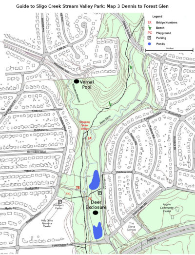 The trail from Dennis Ave to Forest Glen Rd is .5 miles long. South of Dennis Avenue, the hiker-biker trail passes briefly through a meadow— pause to look for wildflowers—, then plunges back into the woods. After about a quarter of a mile, Wheaton Branch joins Sligo. A very pleasant quarter-mile side trip on the unpaved path on the right side of the Branch leads to a sturdy vernal pool, carved out by the government a decade ago for the convenience of amphibians. A “vernal” pool usually dries out by late summer and thus can’t sustain fish that would eat the amphibians. The park, alas, does not teem with amphibians, but we do have a reasonable assortment (on the FOSC website check out “Plants and animals/ amphibians”, for a list PLUS actual recordings of frog calls).
A return to the main trail is accomplished by walking a short block up Woodman Avenue, where a bridge is available to carry one to the other side of Wheaton Branch. Note the stream restoration techniques that have been used. They not only stabilize the stream bed, add water critter habitat, and look nice too.
Shortly after returning to the main trail, a playground appears on the right. A side trail over the Creek delivers looks at two small storm-water ponds. Both contain Wood Duck houses that are occasionally used. The ponds are also home to turtles, mostly “sliders”. This wetland also contains a couple of fenced areas called “deer exclosures”. They are sadly demonstrating that the over-abundance of deer in the park is having a bad effect on the diversity and succession of plants in the park. This area was also the site of a one-time government experiment to see if goats could be used to manage non-native invasive plants. As was suspected, the goats ate pretty near everything, which made the project impractical (but adorable).
The last part of the main trail in this portion of the park passes by woods on the left (by the creek) and a meadow on the right. This edge area is typically a good place to see a variety of song birds and hawks. Baltimore oriole nests have been seen hanging in the trees.
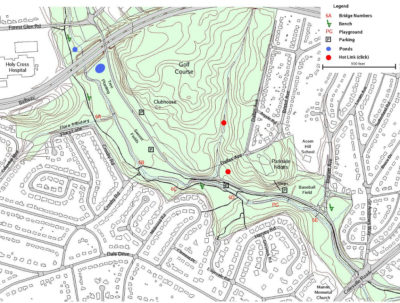 This portion of the hiker/biker trail is about one mile long, barring exploration of tempting side trails. Heading downstream on the bike-trail from Forest Glen, one travels through a meadow prior to passing under the Beltway. The trees around the open area are good places to see Red-shouldered and Red-tailed hawks, both of which nest in the watershed. After the beltway under-pass, there is an area to the left of the trail that was cleared of invasive vines and planted with trees about six years ago. They are protected by fencing to keep deer from destroying them. The deer population is considered by Park biologists to be several times larger than can be sustained by the local ecosystem. One of their impacts is to make it difficult for small trees and shrubs to fill in under the large ones. There is a discussion of the impact of deer in the FOSC website under Plants and Animals.
A little farther, a bridge carries the trail over the Flora Lane Tributary. An unpaved trail follows it upstream until it goes under a street near Georgia Avenue. To make this trail a loop, there is a meandering trail that circles back along the hill between the Beltway and the stream. In a couple of places the stream bed had been engineered to slow its flow and improve habitat for stream critters. These include American Eels, the largest type of fish that is known to inhabit the waters of Sligo.
The paved trail continues downstream skirting “Crosby Woods” on the left— a good place to notice flowers and birds, especially woodpeckers. After the woods, the trail splits: one part passes over a bridge over Sligo; the other stays on the right bank. The one on the bank skirts a wet area that contains a thriving colony of Skunk Cabbage (Symplocarpus foetidus). That trail rejoins the other path after passing over a bridge a couple of hundred yards later by a popular playground where another tributary joins the main stem. Both trails have several interpretive signs put up by Montgomery Parks about eight years ago. They explain various natural features of the local stream area.
Across the creek from “Crosby Woods” is a mowed play field that is regularly used for soccer. It has an official parking lot and during the warmer months, an out-house. Upstream is a meadow area that is being gradually naturalized by planting native plants, removing non-native plants, and less frequent mowing. Just upstream from the meadow is a small complex of storm water ponds that help with run-off from the Beltway. Beaver, Red-winged Blackbirds, herons, and butterflies have all been seen here. Plus a pair of Canada geese regularly raise young by the ponds.
Across from the Parkway from the soccer field is Sligo Creek Golf Course. The 9-hole course is the oldest public course in the County. It dates back to 1923 when it was called Argyle. The current clubhouse built in 1958 has FLUSH TOILETS AND A SIT-DOWN CAFE.
Back at the juncture of the paved paths by the play-ground, there is a small parking lot near where Dallas Avenue intersects with the Parkway. The paved bike path continues along the left bank of the creek to Colesville Road. While interesting enough, the unpaved trail on the other side of the creek is less crowded, and has a more natural atmosphere as it snakes around large trees and skirts a wet-land. It also affords more chances to see such flowers as Spring Beauty (Claytonia virginica), Trout Lily (Erythronium americanum), and Mayapple (Podophyllum peltatum) in season. The wet-land even has a miniature cypress swamp (one medium tree with about ten knees).
If you have visited the area near the play-ground too many times, an alternative to the paths noted above, is to take the hill up Dallas Ave to take a peek at the Park Headquarters. Starting at the intersection with the Parkway, walk up Dallas. To your left, there are glimpses of the golf course; to the right a nice woods. At the top of the hill, the Headquarters is on your right. The one-story former school built in 1934 as Parkside Elementary, has been nicely converted to house the Headquarters of Montgomery Parks. During business hours there are various brochures and maps just inside the entrance. Montgomery County has one of the finest and most extensive collection of parks in the whole country. Be grateful.
You can rejoin the bike trail after leaving the Headquarters by heading east down the driveway, then going right on Brunet Ave back to the Parkway.
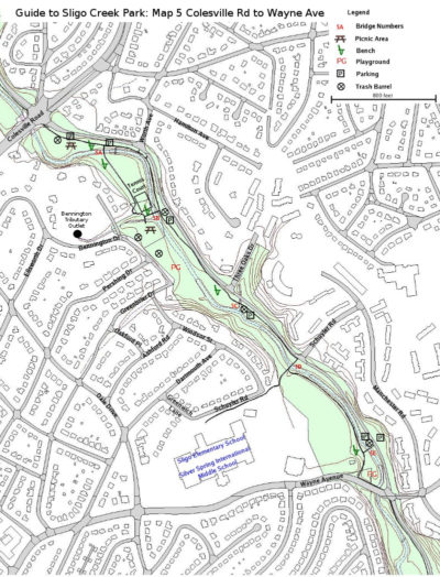 This portion of the hiker/biker trail is 0.7 miles long. If on a bicycle, you will probably want to just follow the paved trail down to Wayne. It stays on the left bank of the creek for about a half mile to where Schuyler Road intersects with the Parkway. There the trail goes over the creek and continues the last two tenths of a mile to Wayne Ave. Unfortunately the creek is often out of sight, and this portion of the trail is rather congested.
Walkers can add some zest to their experience by crossing over the creek at the first footbridge past Colesville Road. The unpaved trail that heads upstream has good views of large rocks and beaches in the creek bed. A paved trail heads downstream past a tennis court to Bennington Tributary. On the walk down, there are a number of attractive trees to enjoy, including a spectacular American Beech (Fagus grandifolia), several White Pines, a Norway Spruce, and numerous large Tulip Trees.
After a walk up Bennington Drive along the tributary for about a quarter of a mile, one can see the above-ground beginning of this branch of Sligo. It consists of two five-foot diameter outlets. Rainfall that hits much of downtown Silver Spring to the east of Georgia Avenue finds its way to this drainage ditch. As one can imagine, since this storm water contains urban run-off, it is a source of regular, and sometimes, really nasty contributions to Sligo. Neighbors keep an eye on the condition of the stream, and often call in problems to the County government. In the FOSC website look under “Water Quality/ Water Watch Dog” for more on this topic. However, this unassuming portion of the waterway is still a place to discover snails, frogs, Mallard ducks cruising its surface, as well as fish such as black-nose dace and white suckers.
Where Bennington Tributary joins Sligo Creek, there is a footbridge that rejoins the main bike path. Staying on the right side, however, a paved trail soon leads to a playground. Leading from the playground, an unpaved rough trail continues downstream to where it connects with the bike path by the footbridge at Schuyler Road. This trail is definitely too rough for bikers but has the virtue of being quite interesting for walkers.
Below the footbridge at Schuyler, the bike path is hemmed in by a chain-link fence to the right and the bank of the creek to the left. On the other side of the fence is the football stadium and track for the former setting of Montgomery Blair High School. The High School was built on the banks of Sligo Creek in 1935, but moved to a location a couple of miles away at the intersection of University Boulevard and Colesville Road in 1998. Sligo Elementary School (mascot, “the salamanders”), and the Silver Spring International School share the renovated buildings of “Old Blair”.
Just before Wayne Avenue, the bike path goes through a small playground. If you know your trees, you might identify a good-sized Swamp White Oak (Quercus bicolor) growing close to the creek. It is the only known example of that oak in the park. Wayne Avenue may eventually carry the “Purple Line” across Sligo Creek, but at this time (October 2016) construction has not started.
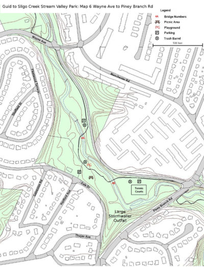 This portion of the hiker/biker trail is 0.5 miles long. Below Wayne, the bike path continues close to the Parkway for about another quarter of a mile. Just past a small parking area it travels over a footbridge. At this time (Ocotber 2016) between the parking area and the creek there is a shallow 80 foot pond that drains into the creek at it’s lower end. Right now it looks pretty raw, but eventually it is expected to be transformed into a sizable rain garden that may also function as a vernal pool. Visible across the parkway tree enthusiasts should note the fine specimen of a Yellowwood (Symplocos tinctoria). Due to its size it is the current County Champion. However Yellowwoods are rarely found away from the Eastern Shore.
Back at Wayne Avenue, walkers may wish to try out the unpaved path that follows the right side of the creek. The walk through the woods has more atmosphere but may be soggy. This path reconnects with the bike path on the right side of the creek below the footbridge mentioned in the previous paragraph. Near where the two paths reconnect, there is a sizable White Ash (Fraxinus americana) by the creek. Unfortunately, like other ash trees in the County, it’s days may be numbered, because of the serious threat posed by the Emerald Ash Borer, which is decimating ash trees throughout the U.S.
Walkers are encouraged to work their way down to the creek at this point to take in the enchanting view as it passes by the playground found here. Along the whole length of the creek from March through October, attentive birders may be graced with the sight of Yellow- or Black-crowned Night herons in the trees or checking the creek for fish, but this spot is known as a hot spot.
After the playground the path re-crosses the creek and goes by a popular tennis court (with lights). Walking around behind the court, one can take a gander at a steep bend of the creek. A dramatically large outfall drains a big area of mixed residential and commercial establishments into the creek here. That makes it a useful spot to monitor for bacteria and other contaminants. Check out Water Quality on the website to learn more about the condition of creek water. Friends of Sligo Creek has a Water Quality Committee that actively monitors water quality and promotes action to improve the current not very good situation.
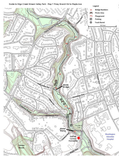 This portion of the hiker/biker paved trail is about 0.8 miles. It might be called the Sligo Gorge since it is mostly hemmed in by high ridges on both sides. It also has more twists and turns along the way. The trail crosses the creek eleven time between Piney Branch Road and New Hampshire Ave. Note that on most Sunday afternoons the Parkway from Piney Branch to Maple Avenue, and again from Maple Avenue down to Old Carroll Avenue, is closed to cars.
The trail passes through dense woods for about a half mile before opening up a little for a small meadow and parking area just upstream from a handsome stone bridge at Park Valley Road. The bridge was built in 1931 and has been deemed worthy by the State Highway Administration to be included in the National Register of Historic Places, so give it a more than a glance before it is replaced sometime in 2017. The streets of the steep Sligo Hills neighborhood up from the bridge were recently improved to better protect the creek from storm water damage.
On the other side of the bridge, the trail continues to a popular picnic area at Kennebec Street. It includes a playground and good access to the creek. Past the park, Comstock Branch comes in from the right. This modest stream carves a charming glen in the hillside alongside Mississippi Avenue for a couple of blocks up to Piney Branch Road.
A little further along, the remains of an old concrete dam can be seen. It was used from about 1900 until 1930 to capture drinking water for Takoma Park and nearby communities. The U.S. Geological Survey maintains a water monitoring station adjacent to the dam. Look for a white box with a tube in the water. Data from it can be perused on our website, under Water Quality.
Rachel Carson rented a house in 1943-1944 a stone’s throw from the creek, near the intersection of Maple and the Parkway on the right bank of the creek. The small bungalow was replaced by the apartment building on the spot sometime in the 1950s. See Rachel Carson Lived Here on our website.
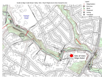 This portion of the hiker/biker trail is 1.0 miles long. Following Maple Avenue south takes one to an Historic district of Old Takoma Park. It has a good stock of Victorian and Craftman style homes from as early as 1890. BTW, the Takoma Metro station can also be reached by following Maple Avenue for about a mile, then going west on Carroll Street for a few more blocks.
Commanding an approximately 50 acre site on the hill over-looking the creek from the north, is Washington Adventist Hospital and The Washington Adventist University. Both date back to the early years of the last century. The hospital is scheduled to leave the site during the next decade, but the University of some 1500 students will stay.
The boulder-strewn creek flowing by the hospital reveals the ancient geology of the area. Beginning some 450 million years ago sediment collected at the bottom of a narrow sea was subjected to tremendous heat and pressure from over-lying mountains likely as massive as the current Himalayas. Here and there quartz may be seen; just above the Carroll Avenue bridge, a striking vein spans a couch-shaped feature known as Meditation Rock. See Sligo’s Amazing Geology for more details and photos of the local geology.
On the right bank of the creek about a hundred yards below Maple Avenue, a stream called Brashear’s Run joins the creek. The visible part of the tributary is only a stub of a drainage that extends underground all the way up to the ridge where the Metro runs. Water from the two six- foot outlets regularly contain detergents and other contaminants from somewhere in the underground labyrinth. The Friends of Sligo are working with the County to try to pinpoint where these illegal discharges originate (see Water Quality). Despite the problems with water quality, even in this waterway, waterfowl including Mallards, Wood Ducks, and Black-crowned Night Herons are occasionally seen, probably helped by the cover provided by the thick woods here.
Moving along, Carroll Avenue Bridge is the most striking man-made structure in the park. The current graceful concrete bridge, built in 1932, is being reconstructed at this writing (October 2016); an intriguing process to watch. The temporary pedestrian bridge reachable from Carroll Avenue provides an excellent vantage point of the construction and the creek. Our website contains plenty of information with photos of the Historic Bridges over Sligo Creek. Among other things, it describes the previous bridges at this site, including the tragic accident that occurred during the demolition of the one built in 1909.
The paved trail passes under the bridge, then crosses the creek twice in rapid succession, settling down on the left bank. After a few more hundred yards, the creek and trail make an abrupt turn skirting a playground. As there are welcome benches and picnic tables, this is a fine place to pause and reflect on the story of the notorious Glen Sligo Hotel.
The playground and surrounding level area was once a mill pond. Back in 1812, a mill was built where New Hampshire Avenue now crosses the creek. Upstream about where Flower Avenue now crosses the creek, a dam was built creating a pond. From the pond a millrace carried water more or less following the route of the Parkway to power the mill.
By 1900, the mill was no longer operating, and the site was acquired by Alva M. Wiswell, a real-estate promoter and investor. He built a hotel on top of the hill rising from the right bank of the pond along present day Heather Avenue. The Glen Sligo had eight rooms, a bar and large dance pavilion. A trolley line called “the Dinky Line” connected the resort to down-town Takoma Park. As added attractions he re-furbished the mill and pond for visitors. Unfortunately, a storm damaged the pond in 1901 just when Mr. Wiswell was suffering financially from an unfortunate investment in a gold mine out west.
A group of gamblers bought the hotel and after hooking it to telegraph lines, by 1903 were proud owners of a successful establishment specializing in horse race track information and convenient placing of bets. There was also a pool room on the premises. This whiff of unsavory activities rankled certain members of the community, who encouraged Sheriff Ben Hardesty to take action. Despite some legal uncertainties such as not having a warrant, the Sheriff led a raid that sent a strong signal to the owners of the enterprise. By 1904 the hotel had closed; by 1905, the trolley tracks were removed; and by 1920 the hotel and mill were torn down. This colorful chapter in the history of the area is more thoroughly explored, supplemented by photos, in our website (Glen Sligo Hotel).
The trail from Flower Avenue to New Hampshire Avenue crosses the creek three times in a fairly short distance. Long Branch comes in from the north after the last footbridge, but there is no convenient way to explore that part of the park from the main paved hiker/biker trail. Just up from New Hampshire Avenue, a bronze memorial notes the tragic deaths of two firemen (Robert Harman Jr. and Robert C. Hobstetter). They drowned there in 1969 while attempting to rescue a family trapped by flood waters from a heavy storm.
 This last 0.7 mile portion of Sligo Creek lies in both Montgomery and Prince Georges Counties. A paved hiker-biker trail runs through it and hooks up with the Northwest Branch bike trail, but the Sligo Creek Parkway ends at New Hampshire Avenue.
On the downstream side of New Hampshire Avenue, the trail runs parallel to the roadway on a boardwalk for about 200 feet. At the end of this there is a bike repair station that contains a pump and a set of tools, cleverly secured from thievery. There is also a detailed map of area bikeways. The paved trail then veers away from NH Avenue and passes through a pleasant landscaped area that was developed in about 2009 by the combined efforts of Hillwood Manor residents, the City of Takoma Park, and MC Parks. The plantings are mostly native but you may notice some copper-leaved Redbud trees unlike anything else in the park.
The trail continues on a footbridge over a dramatically deep gorge dug by Sligo. Farther along at the Hillwood Manor playground a drinking fountain is available in season (and swings). FOSC maintains a “signbox” there, and MC Parks has another map-sign. The trail crosses Sligo twice in this twisty and scenic stretch with good views of bedrock and a beach where the creek makes a curve. Just after the second bridge on the far bank there is a colony of old Mountain Laurel (Kalmia latifolia) whose blooms compel viewing round-about Memorial Day.
The trail continues through a steep wooded valley for another five hundred yards where it suddenly opens to reveal the right-of-way (ROW) for a huge power-line. The ridge to the left of the trail contains a good population of Chestnut Oak as well as Arrow-leaf and Maple-leaf Virburnum (Viburnum dentatum and V. aceriforlim). If you are curious about a white diagonal line painted across the trail a bit before the ROW, it represents the MC/PG County border.
The rough meadow maintained by the electric utility is one of the few places where native creatures and plants adapted to those conditions can flourish. Through an arrangement worked out in 2008 between Pepco and FOSC, the ROW is subject to limited mowing. In 2013 and 2014, a group led by ecologist Rhonda Kranz surveyed the bee population, and the flowering plants were surveyed by Michael Wilpers and Bruce Sidwell. They identified 97 species of bees and 120 species of flowering plants. The June 2016 newsletter explains the effort. The list of bee species can be viewed on our website. In 2023, FOSC Natural History chair Michael Wilpers worked with state Del. Lorig Charkoudian, Sen. Malcolm Augustine, and the Maryland Chapter of the Sierra Club to pass a new Maryland bill that exempts powerlines from county and municipal “weed” ordinances.
 This portion of the hiker/biker trail is 1.5 miles long. After crossing East-West Highway the terrain becomes noticeably flatter. Welcome to the Coastal Plain! From here on out to Ocean City, the Piedmont Plateau disappears beneath the eroded debris of the Appalachians— kind of like what happens to your basement when you live in a house too long. There are no hills for Sligo Creek to carve through, so she meanders here and there through the sand and gravel. Just past the highway, Takoma Branch comes in from the right. Unfortunately there is no trail that can be used to explore this tributary back to its sources in Takoma Park.
After crossing Riggs Road (1.1 miles from Northwest Branch), the stream is confined to a concrete bed for a few hundred feet to keep it from flooding the low-lying neighborhood. The concrete bed is then replaced by a dike for another half mile. To the right of the dike are playing fields that border the creek for about half-a-mile. To the left of the dike a section of road is named Sligo Parkway.
Due to a border of woods, the creek is not visible from the hiker/biker trail. But rather than gliding innocently by, one should venture over to the stream bed for a gander. The stream is broader than ever, and is periodically broken up by nice-looking stone structures designed to channel the creek and slow down its flow during stormy times. There are low places in these dams to allow fish to move up and down the creek. Before the area was extensively settled, shad (a tasty fish) used to migrate up Sligo to spawn in spring. Due to barriers and pollution they left the scene but still come up nearby Northwest Branch, so one can hope for their return.
Close to the end of the stretch of ball fields, stands a huge old Eastern Cottonwood (Populus deltoides). In late Spring, its cottony flowers are strewn around like a light snow. This area by the creek has the largest concentration of Cottonwoods in the watershed.
As the trail re-enters a wooded area for the first time since crossing East-West Hwy, it crosses a bridge over a small tributary but the trail stays to the left of the creek, which is still not visible from the trail. Just beyond the bridge to the left of the trail, a chain-link fence topped with barbed wire parallels the trail. It protects a complex of antennas erected just after WWII and is now owned by Red Zebra Broadcasting.
After about a quarter-mile of woods and the fenced off area, a bridge suddenly appears. It carries the Sligo hiker/biker trail over Northwest Branch where the trail connects with the Northwest Branch trail. The elevation above sea-level here is about 38 feet, approximately 400 feet lower than the highest reaches of the watershed found back in Wheaton.
By the way, following the Northwest Branch trail downstream less than a mile will bring the traveler to the West Hyattsville Metro Station. Near that same area of the Branch upstream from Queens Chapel Road, one may find 120 million year-old petrified (carbonized) driftwood on the bottom of the creek from the days when the area was covered by a shallow sea.


